Four
delegates from Ogilvie Geomatics recently attended the annual ICES BIM seminar.
We all pleaded guilty with not fully familiarising ourselves
with the BS1192 document. BIM is not
going to go away and as a profession we need to be prepared.
There is a working group – Survey4BIM that is part
of the government task group on BIM. For
further info read below and visit:
http://www.bimtaskgroup.org/survey4bim/
Survey4BIM
Survey4BIM is a cross-industry group open to all
organisations involved in the survey, collection, management, processing and
delivery of geospatial information within a BIM context.
The groups make up is reflective of the sector,
involving clients, contractors, consultants, suppliers, sub-contractors,
institutions and other bodies.
Our mission is to provide a forum for survey
organisations and industry professionals to collaborate and share their journey
putting “BIM into practice”, and to provide best practice guidance documents on
survey matters relating to BIM.
Goals
In order to achieve this, the Survey4BIM Management
Committee has identified seven goals
1.Provide
leadership in establishing how surveyors provide an integral and continuous
role to the BIM process and the importance of geospatial information.
2.Share
knowledge and learning between its members
3.Establish
collaborative links to Universities and academia – education of the full
supply-chain
4.Produce
and publish best practise guidance to organisations, clients and industry
professionals on survey matters relating to BIM in the form of Technical Notes
and Guidance Documents.
5.Coordinate
the Survey4BIM related activities undertaken by survey bodies and institutions.
6.Promote
survey related case studies, which demonstrate best practice and the integrated
management of geospatial information across all stages of the asset lifecycle.
7.Represent
the surveying profession in wider discussions on BIM and act as a partner to
the Cabinet Office BIM Task Group.
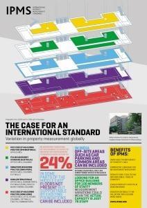
New International Property Measurement Standards (IPMS)
Property is measured differently throughout the world. This causes inconsistencies that impact on our globalised market: research suggests that measurements can deviate by up to 24% depending on the approach used.
Such deviation has prevented us from comparing like with like and can significantly hinder decisions made by investors, occupiers and indeed all property users.
To address this issue the International Property Measurement Standards (IPMS) Coalition was formed in May 2013, made up of the world’s leading professional bodies in real estate, property and construction. Ogilvie Geomatics personnel are aware of these changes and are capable of carrying our surveys compliant with the IPMS.
IPMS: Office Buildings
The first in a series of IPMS standards, IPMS: Office Buildings, was published on 24 November 2014.
Over the next two years, IPMS: Office Buildings will be joined by IPMS: Residential Buildings, IPMS: Industrial Buildings and IPMS: Retail Buildings.
These standards will also be fully incorporated into new guidance issued to RICS members (subject to consultation). Together, they will ensure that chartered surveyors are equipped to provide IPMS measurement services in response to the anticipated, growing market demand for international consistency in property measurement.
For more information check out the following link:
We recently attended The Survey Association (TSA) health and safety seminar at Leica HQ and was shown this video at the start of the day - we felt that it was important we shared it on our blog and have asked all of our staff to view the video. "Kate's Story" is a video produced internally by Jacobs that tells the tragic story of Jacobs employee Kate Carpenter (London, UK), whose husband, John Kinns, also an employee, lost his life as the result of injuries sustained in the field. The video has been shown and discussed at office meetings across the globe and has had a profound impact within the company.
The video is now available for employees to view and share with family, friends, business partners, and clients.
Please take Kate's message to heart. View the video at the following link: Kate's Story
We make maps and plans everyday at Ogilvie Geomatics which is why the article by John Howell of Aberdeen University was of particular interest (see below). To read the full article visit:
Two centuries of map-making – from William Smith’s survey to satellites
This year marks the 200th anniversary since William Smith published his life’s work, a geological map of England and Wales, in 1815. While “Strata Smith” and his map are well-known among geologists, this humble man and his amazing map do not receive the attention or wider recognition they deserve. Smith’s achievement was arguably as significant as Darwin’s, yet he resides in relative obscurity.
William Smith, (1769-1839).Hugues Fourau
Smith’s achievement was remarkable for a number of reasons. He made the scientific leap that the rocks of the Earth’s crust could be overlaid onto a basic topographic map, in doing so giving birth to the science of geology. He also did this in the face of considerable social prejudice – at a time when the scientific community were landed gentry and gentlemen of leisure the idea that Smith, a lowly surveyor, could come up with such a revolutionary concept was derided. His work was plagiarised and he was bankrupted, spending time in debtor’s jail, before his eventual vindication just before his death in 1839. The fact that he single handily managed to map the whole of England and Wales, in his spare time, to produce a map that is remarkably accurate even today is to any modern geologist truly breathtaking.
Smith’s Stratigraphic Map of England and Wales.William Smith/BGS
Click to enlarge
So impressive were Smith’s achievements that very little changed for the next 170 years. Geological maps continued to be drawn up in much the same way as he had demonstrated. Geologists walked the hills and dales, identifying rocks with hammer and hand lens, then marking the boundaries between the layers onto a topographic base map. The basic tools were the compass, the magnifying glass, the hammer, coloured pencils and a map. Today, every geology student still spends five or six weeks of their final summer at university investigating the geology of an area and marking it onto a map in much the same way that Smith worked.
In with the new
Which is not to say that nothing has changed in mapping. Since the earliest maps we have strived to explain graphically the spatial relationships between places.
The earliest maps were mere estimation. The first real advance was the introduction of measurement into the map-making process; the advent of the compass allowed mapmakers to describe orientation and direction in a systematic manner, while the barometer allowed estimates of altitude and the sextant gave information on position. These advances led to the first real topographic maps where the map is an accurate representation of the location of both natural and man-made features. By Smith’s time, we were quite good at generating basic maps although the processes for surveying were slow and laborious.
Nicolas Desliens' 1566 map of the world, originally depicted with south at the top.Nicolas Desliens
Click to enlarge
The big advance after Smith came in the early 20th century with the arrival of aircraft. For the first time the map maker could actually see a true bird’s eye view of the features that were previously only inferred from measurements on the ground. Consistent sets of scaled photographs allowed much faster mapping of the plan-view relationships between features.
The introduction of stereoscopy and photogrammetry (taking measurements from photographs) exploited the distortion apparent in a circular camera lens when applied to a square or rectangular image. By using overlapping photographs the three-dimensional topography of the features in the photo could be mathematically reconstructed, speeding up terrain mapping.
From physical to digital tools
The arrival of the computer in the early 1970s brought the first Digital Elevation Model, a 3D model created from elevation data, and greater use of the wealth of data arriving from the growing number of orbital satellites.
A ‘point cloud’ depiction of Monmouth Castle generated by lidar.John Cummings, CC BY-SA
Around the same time came the evolution of LiDAR (Laser Detection and Ranging), which – by analogy with radar – creates a map based on the reflection of a laser beam (rather than radiowave). Vast “point clouds” are built up by systems measuring hundreds of thousands of points per second, providing maps of incredible precision.
The 20th century’s final major advance was the evolution of GIS, Geography Information Science, bringing together systematically vast libraries of geographic data. By the turn of the millennium had the capacity to remotely survey our world (and even other planets, as seen with Google’s maps of Mars and the moon) and to draw up extremely accurate maps populated with layers of data.
Combining the best
The tools have changed for 21st century geologists following in Smith’s footsteps. In the field we now use GPS to accurately locate our position on tablet computers. Compasses and inclinometers are now integrated into our smartphones, and LiDAR machines can map cliffs with centimetre precision in minutes. New methods such as hyperspectral scanning, which uses the variable absorbency objects have to infrared light to automatically identify types of rock, terrain or vegetation, are now routine.
Data are stored and published digitally using systems such as the apps and websites of the British Geological Survey making them widely available to scientists and the public alike. So 200 years on, we may ponder what Smith would have made of the legacy of his first map. With such a struggle for recognition during his life, hopefully he’d feel vindicated in the direction geology took afterwards.
We attended an interesting event hosted by the Mike Rhodes of the MK50 Club on 13th October 2014. The event covered aspirations for the construction industry as set out by the government by 2025.
Working together, industry and Government have developed a clear and defined set of aspirations for UK construction.
Both Loy Surveys and Longdin and Browning Surveys were some of the first members of the The Survey Association (TSA). Stan Longdin was actually at the first meeting of the organisation on the 3rd January 1974.
More details can be read about this meeting and how the the TSA was formaed in a post by Rory Stanbridge on the TSA website:
www.tsa-uk.org.uk/happy-35th-birthday-tsa/
The TSA has done great work over the years in bringing the industry together and providing guides for surveyors and clients alike. Keep up the good work up!
The latest edition of Measured surveys of land, buildings and utilities - RICS guidance note contains a useful table outlining accuracies bands, requirements and features depending on the Survey type/use and legacy output scale. In our opinion this table simplifies the often over-complicated subject of accuracy and scale and should be used by clients and survey professionals alike. See below:


.jpg)